Gasa Dzong, formally known as Gasa Tashi Thongmon Dzong, is a fortress-monastery and the administrative centre of Gasa District in the remote northern highlands of Bhutan. Situated at an elevation of approximately 2,800 metres, it is one of the most isolated dzongs in the country and lies near the renowned Gasa Tshachu hot springs.
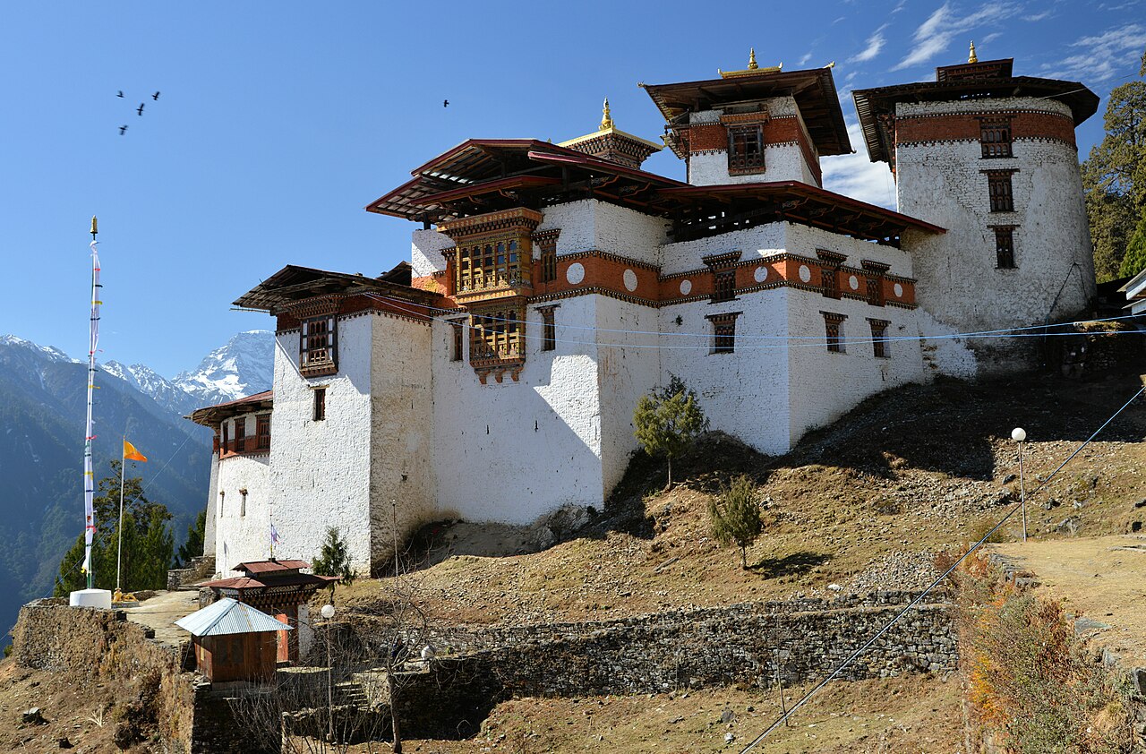
Gasa Dzong (Dzongkha: མགར་ས་རྫོང), formally known as Gasa Tashi Thongmon Dzong ("Fortress of the Auspicious Hill"), is a fortress-monastery and the administrative headquarters of Gasa District in the remote northern highlands of Bhutan. Situated at an elevation of approximately 2,800 metres on a hilltop overlooking the Mo Chhu valley, it is one of the most isolated and least accessible dzongs in the country, reachable until recently only by a multi-day trek through mountainous terrain.[1]
Gasa District is Bhutan's least populated district and borders Tibet to the north. The dzong serves as the administrative centre for a vast territory of high-altitude valleys and alpine pastures inhabited primarily by semi-nomadic yak herders known as Layaps and Lunaps. The area is also renowned for the Gasa Tshachu, a cluster of natural hot springs located along the banks of the Mo Chhu below the dzong, which have attracted pilgrims and visitors for centuries for their reputed medicinal properties.[2]
The dzong's extreme remoteness has preserved both the fortress and its surrounding cultural landscape in a remarkably traditional state, making the Gasa region one of the last places in Bhutan where pre-modern highland lifeways remain largely intact.
History
The original fortification at the Gasa site was constructed in 1646 by Zhabdrung Ngawang Namgyal's governor, Tenzin Drukdra — the same builder responsible for Drukgyel Dzong in Paro. The fortress was established as part of the Zhabdrung's systematic programme of dzong construction, which sought to extend centralised authority into every region of the country. Gasa Dzong's primary purpose was to guard the northern frontier against incursions from Tibet and to assert administrative control over the highland communities of the upper Mo Chhu valley.[1]
The dzong's strategic position was significant during the recurrent Tibetan-Bhutanese conflicts of the 17th and 18th centuries. The Mo Chhu valley was one of several routes through which Tibetan forces could penetrate into western Bhutan, and the fortress served as an early warning post and defensive bastion along this corridor. Historical records indicate that the dzong's garrison was reinforced during periods of heightened tension with Tibet.[2]
The dzong was renovated and partially rebuilt on several occasions. Like many Bhutanese dzongs, it suffered fire damage and earthquake damage at various points in its history. The circular shape of the fortress — unusual among Bhutanese dzongs — has been maintained through successive reconstructions, suggesting that it was considered a distinctive and intentional aspect of the original design.
Architecture
Gasa Dzong is architecturally distinctive among Bhutanese dzongs for its roughly circular plan, in contrast to the rectangular or irregular quadrilateral layouts that characterise most other dzongs in the country. The circular design may reflect the topography of the hilltop on which it sits, with the walls following the contour of the summit to maximise the defensive use of the natural terrain.[1]
The dzong features a central tower (utse) that houses the principal chapels and monastic quarters. The outer walls, constructed of rammed earth reinforced with stone, enclose a courtyard that serves as the gathering space for administrative functions and religious festivals. The walls are punctuated by small window openings — practical for defence while limiting heat loss at the dzong's high altitude.
The fortress is relatively compact compared to the great dzongs of the western valleys such as Punakha Dzong or Tashichho Dzong, reflecting both the limited population of its district and the logistical challenges of transporting construction materials to such a remote site. Nevertheless, the dzong incorporates the full complement of administrative offices, monastic quarters, and chapels required of a district headquarters in the Bhutanese administrative system.
Religious and Cultural Significance
The dzong houses a monastic community and serves as the venue for the annual Gasa Tshechu, a festival that draws participants from the scattered highland communities across the district. The tshechu features traditional masked dances and religious ceremonies, and it is one of the few occasions each year when the dispersed population of the district gathers in one place. For the semi-nomadic Layap and Lunap communities, the festival serves important social functions beyond its religious purpose, providing an opportunity for trade, social exchange, and the renewal of community bonds.[3]
The Gasa Tshachu hot springs, located approximately one hour's walk below the dzong along the Mo Chhu river, have been used for centuries as a site of healing and purification. Bhutanese traditional medicine attributes therapeutic properties to the mineral-rich waters, and bathing in the springs is considered beneficial for ailments ranging from arthritis to skin conditions. The hot springs attract visitors from across Bhutan, particularly during the winter months, and have become an increasingly popular destination for international trekkers.[2]
The broader Gasa District is also the gateway to the Snowman Trek, widely regarded as one of the most challenging long-distance treks in the world. The 25-day route traverses the remote northern highlands of Bhutan, passing through landscapes of exceptional natural beauty and cultural isolation.
Current Status
Gasa Dzong continues to function as the administrative and monastic centre of Gasa District. In recent years, the construction of a motorable road linking Gasa to Punakha has dramatically improved access to the formerly isolated dzong. Where once visitors had to trek for several days to reach Gasa, the journey can now be completed by vehicle, albeit on a narrow and winding mountain road that remains subject to landslides and seasonal closures.
The Bhutanese government has identified Gasa as an area for sustainable tourism development, capitalising on the hot springs, the Snowman Trek, and the region's pristine natural environment. The dzong itself has undergone conservation work to address structural deterioration caused by the harsh climate, and improvements to the hot springs facilities have been undertaken to accommodate increasing visitor numbers while preserving the traditional character of the site.[3]
References
- Gasa Dzong, Wikipedia
- Gasa District, Wikipedia
- Gasa Dzong, Tour My India
See also
Trashigang Dzong
Trashigang Dzong (Dzongkha: བཀྲ་ཤིས་སྒང་རྫོང), meaning "Fortress of the Auspicious Hill," is the largest and most important dzong in eastern Bhutan. Built in 1659, it served as the seat of power for the governance of eastern Bhutan and remains the administrative centre of Trashigang District, the most populous district in the country.
places·5 min readLhuentse Dzong
Lhuentse Dzong, formally known as Lhundrup Rinchentse Dzong, is a fortress-monastery in the Kurtoe region of northeastern Bhutan. It serves as the administrative and religious centre of Lhuentse District and is revered as the ancestral home of the Bhutanese royal family, the House of Wangchuck.
places·5 min readGasa Tshachu (hot springs)
Gasa Tshachu is a group of natural hot springs in Gasa Dzongkhag in northern Bhutan, near the Mo Chhu river below Gasa Dzong. Long believed to relieve a range of ailments, it is among the most visited tshachu (medicinal hot springs) in the country and a popular domestic pilgrimage and wellness destination. The springs were destroyed by a flood in 2021 and reopened in 2023 after reconstruction.
places·2 min readSimtokha Dzong
Simtokha Dzong (Dzongkha: ཟིམ་སྟོད་ཁ་རྫོང), officially Sanga Zabdhon Phodrang, is the oldest dzong in Bhutan. Built in 1629 by Zhabdrung Ngawang Namgyal at the entrance to the Thimphu valley, it was the first of the great fortress-monasteries that would come to define Bhutanese architecture and governance. It now houses the Institute for Language and Cultural Studies.
places·5 min readDrukgyel Dzong
Drukgyel Dzong ("Fortress of the Victorious Drukpas") is a historic fortress and Buddhist monastery in the upper Paro valley of western Bhutan. Built in 1649 by Zhabdrung Ngawang Namgyal to commemorate victory over a Tibetan-Mongol invasion, the dzong was destroyed by fire in 1951 and has been undergoing restoration since 2016.
places·5 min readHaa Wangchulo Dzong
Haa Wangchulo Dzong is a fortress-monastery in the Haa Valley of western Bhutan. Originally the administrative and religious centre of the Haa region, the dzong has served since 1962 as the headquarters of the Indian Military Training Team (IMTRAT) in Bhutan, a role reflecting the close security relationship between the two countries.
places·6 min read
Test Your Knowledge
Think you know about this topic? Try a quick quiz!
Help improve this article
Do you have personal knowledge about this topic? Were you there? Your experience matters. BhutanWiki is built by the community, for the community.
Anonymous contributions welcome. No account required.